Open Semester Projects and Theses
Seeing Seasons: Temporal Self-Supervised Learning from Outdoor Webcam Networks for Forest Monitoring

In this project you will build SSL models that learn the language of the seasons from thousands of hours of outdoor webcam footage. By exploiting the interplay between visual and meteorological signals, you will develop representations that capture how forests change over time — and use them to predict ecological events before they happen.
Keywords
Self-Supervised Learning · Temporal Representation Learning · Contrastive Learning · Predictive Architectures · Phenology · Outdoor Webcam Networks · Forest Monitoring · Environmental Computer Vision
Labels
Master Thesis
Description
Goal
Contact Details
More information
Published since: 2026-04-30 , Earliest start: 2026-06-01 , Latest end: 2027-06-01
Organization Photogrammetry and Remote Sensing (Prof. Schindler)
Hosts Schindler Konrad
Topics Information, Computing and Communication Sciences , Biology
High-Resolution Air Pollution Mapping: Downscaling Sentinel-5P Data using Multi-Modal Deep Learning

This project investigates the use of advanced deep learning techniques (e.g., diffusion models or vision transformers) to perform spatial super-resolution of satellite-derived air quality data. By fusing coarse Sentinel-5P NO2 observations with high-resolution auxiliary data (such as optical imagery, land cover, elevation, and traffic network data), the project will develop a robust model capable of estimating urban air pollution at the neighborhood level.
Keywords
Deep Learning, Remote Sensing, Air Quality, Multi-Modal, Super-Resolution, Computer Vision.
Labels
Semester Project , Master Thesis
Description
Goal
Contact Details
More information
Published since: 2026-04-25 , Earliest start: 2026-06-01 , Latest end: 2027-04-30
Organization Photogrammetry and Remote Sensing (Prof. Schindler)
Hosts Scheibenreif Linus
Topics Information, Computing and Communication Sciences , Earth Sciences
Implicit Earth: Neural Compression of Geospatial Foundation Embeddings
Global geospatial embedding products provide powerful, pre-computed latent representations of the Earth, but their discrete, grid-based nature requires significant storage and limits sub-pixel analysis. This thesis proposes training an Implicit Neural Representation (INR) to "memorize" these pre-computed embeddings. By training a coordinate-based network to map spatial coordinates to high-dimensional semantic vectors, this project investigates whether the entire latent representation of a region, country, or continent can be compressed into the network's weights while preserving the high-frequency semantics necessary for downstream tasks.
Keywords
Geospatial embeddings, implicit neural representation, location encoder, compression, foundation models.
Labels
Semester Project , Master Thesis
Description
Goal
Contact Details
More information
Published since: 2026-04-25 , Earliest start: 2026-06-01 , Latest end: 2027-04-30
Organization Photogrammetry and Remote Sensing (Prof. Schindler)
Hosts Scheibenreif Linus
Topics Information, Computing and Communication Sciences , Engineering and Technology
Dense spatiotemporal reconstruction of river water levels with deep learning

River water level estimates from satellites are important for hydrological modelling, flood forecasting, and freshwater monitoring, but measurements from in situ gauges as well as observations from satellite altimeters remain sparse in space and/or time. This project applies neural networks trained directly on multi-source observations to reconstruct dense, continuous water level records for major river systems worldwide.
Keywords
Deep learning, Transformer neural networks satellite altimetry, hydrology, time series, graph neural networks
Labels
Semester Project , Collaboration , Master Thesis
Description
Goal
Contact Details
More information
Published since: 2026-04-23 , Earliest start: 2026-07-01 , Latest end: 2027-01-31
Organization Photogrammetry and Remote Sensing (Prof. Schindler)
Hosts Schindler Konrad
Topics Information, Computing and Communication Sciences , Engineering and Technology , Earth Sciences
Synthesizing Aerial Images from Building Roof Geometry

This thesis explores a generative pipeline for creating accurate synthetic aerial imagery using existing geospatial data such as cadaster maps and OpenStreetMap (OSM). The proposed method investigates conditioning-based generative approaches to adapt building roof structures so they align with available labels while preserving the original aerial image style, including roof colors, textures, lighting and surroundings. The motivation is that many existing datasets contain misalignments and outdated annotations when compared to real imagery. By generating corrected yet realistic training data, this work aims to support future tasks such as roof segmentation, vectorization, and automated roof modeling.
Keywords
Synthetic Data Generation Remote Sensing Diffusion Models Geospatial Data Deep Learning Urban Mapping
Labels
Semester Project , Master Thesis
Description
Goal
Contact Details
More information
Published since: 2026-04-23 , Earliest start: 2026-09-01 , Latest end: 2027-08-31
Organization Photogrammetry and Remote Sensing (Prof. Schindler)
Hosts Schindler Konrad , Nicolicioiu Armand
Topics Information, Computing and Communication Sciences , Engineering and Technology
Geospatial AI: Designing Embedding Models for Multimodal Satellite Time Series

In this project, you will develop and evaluate new AI architectures for learning compact embeddings from multimodal satellite time series. The goal is to create models that encode long sequences of Earth observation data into efficient, shareable representations that retain all relevant information for downstream analysis. The project is executed as an onsite project at IBM Research Zurich in collaboration with ETH and provides access to HPC infrastructure.
Keywords
Earth sciences, embedding models, multimodal data, time series, representation learning, computer vision
Labels
Semester Project , Master Thesis
Description
Goal
Contact Details
More information
Published since: 2026-04-22 , Earliest start: 2026-08-01 , Latest end: 2027-03-31
Applications limited to ETH Zurich , University of Zurich
Organization Photogrammetry and Remote Sensing (Prof. Schindler)
Hosts Blumenstiel Benedikt
Topics Information, Computing and Communication Sciences
Reliable Point Tracking in Presence of Non-Lambertian Surfaces

In collaboration with the University of Bologna, you will develop and evaluate novel point trackers robust to the presence of non-Lambertian objects.
Keywords
Point Tracking, Non-Lambertian Reflection, Specular and Transparent Objects, Multi-layered Scene Understanding, Video 3D Understanding
Labels
Master Thesis
Description
Goal
Contact Details
More information
Published since: 2026-03-13 , Earliest start: 2026-04-01 , Latest end: 2026-11-30
Applications limited to ETH Zurich , EPFL - Ecole Polytechnique Fédérale de Lausanne , University of Zurich
Organization Photogrammetry and Remote Sensing (Prof. Schindler)
Hosts Sakaridis Christos
Topics Information, Computing and Communication Sciences , Engineering and Technology
Tree species identification using deep learning
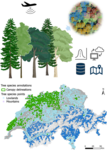
Tree species maps are crucial for effective forest management, biomass assessment, and biodiversity monitoring. Remote sensing products offer flexible and cost-effective ways to assess forest characteristics, while deep learning methods promise high predictive accuracy and transformative applications in forestry. This study aims to apply novel deep learning approaches to detect and identify individual trees and tree species in mixed forests. By addressing the challenges of tree species identification, this research will enhance biodiversity assessment, forest resilience understanding, and management strategies.
Keywords
Tree species identification, computer vision, CNN
Labels
Semester Project , Master Thesis , ETH Zurich (ETHZ)
Description
Goal
Contact Details
More information
Published since: 2026-02-13 , Earliest start: 2025-01-06 , Latest end: 2026-08-31
Applications limited to ETH Zurich , Department of Environmental Systems Science , Department of Civil, Environmental and Geomatic Engineering , Institute of Geodesy and Photogrammetry
Organization Forest Resources Management
Hosts Schindler Konrad , Beloiu Schwenke Mirela , Hangartner Ariane
Topics Agricultural, Veterinary and Environmental Sciences , Information, Computing and Communication Sciences , Engineering and Technology