Automated Large-scale High Carbon Stock Estimation from Space
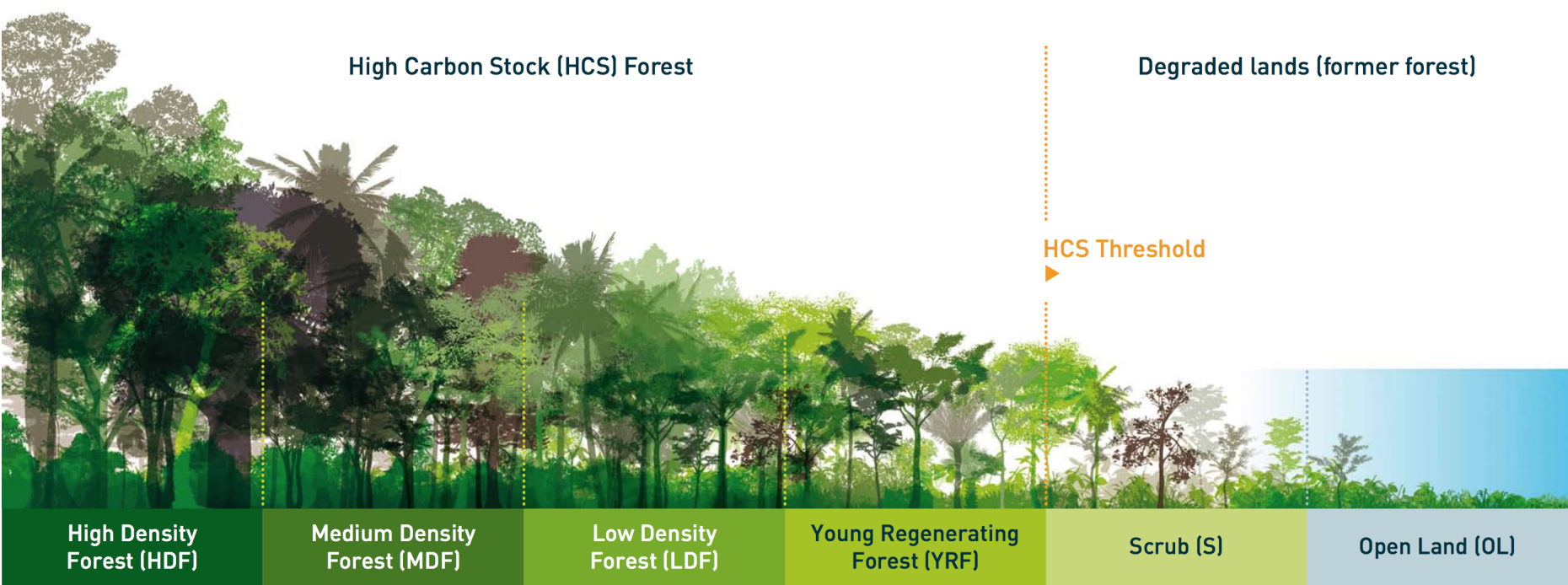
The aim of this joint ETH Zurich-Barry Callebaut project is stopping deforestation and building an objective, highly automated tool to guide sustainable agribusiness. Deforestation is a worldwide problem that accelerates climate change, destroys the livelihood of traditional local communities, leads to extinction of precious animal and plant species etc. Although there is raising global awareness of the consequences of deforestation, measuring it in practice at large scale and at sufficient detail to guide local decision making processes is lacking. In general, measuring deforestation is difficult because it has to factor in carbon, climate, biodiversity, and traditional land-use of local communities. The High Carbon Stock Approach, adapted by Greenpeace and supported by many NGOs and companies, is designed to account for all important factors to protect primary rainforest, while ensuring land use rights of traditional communities.
Although some first ideas towards mapping HCS from space have been proposed, these often use data with low temporal and spatial resolution, which previously was the only available imagery with sufficient coverage. Often, they also use legacy technology (e.g., maximum likelihood classifiers) that does not work well in complex scenarios. In this project, we propose to develop an unbiased, objective, and automated system centered on deep learning that uses satellite imagery acquired by optical and SAR sensors to estimate different HCS categories and warn if primary rain forest is cut down.
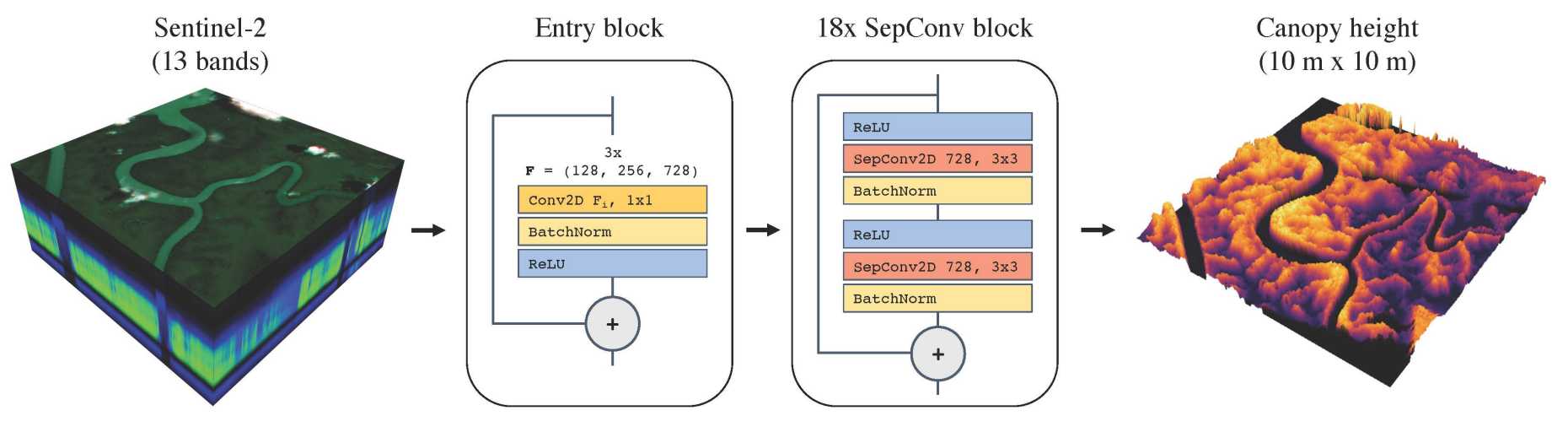
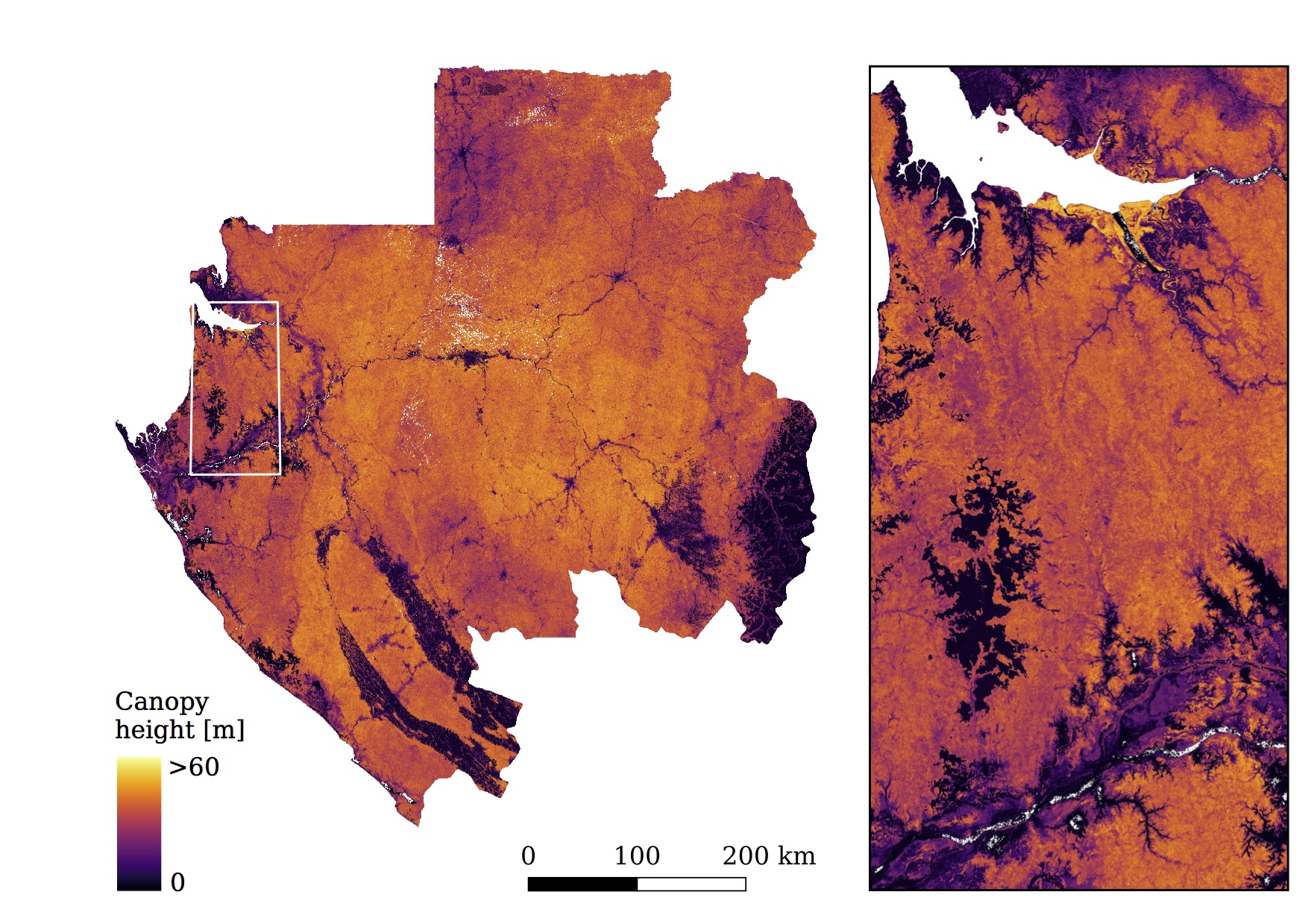
First results on mapping canopy height as a proxy for biomass and HCS at country-scale are shown below. Canopy height can be directly measured with airborne or spaceborne LiDAR. This data has been used as ground truth data to train a deep convolutional neural network to regress canopy height from Sentinel-2 images at a 10 m spatial resolution in Gabon and Switzerland (Lang et al., 2019).
Publications:
Lang, N., Schindler, K., & Wegner, J. D.: external pageHigh carbon stock mapping at large scale with optical satellite imagery and spaceborne LIDAR, arXiv preprint arXiv:2107.07431 (2021)
Lang, N., Kalischek, N., Armston, J., Schindler, K., Dubayah, R., & Wegner, J. D.: external pageGlobal canopy height estimation with GEDI LIDAR waveforms and Bayesian deep learning, arXiv preprint arXiv:2103.03975 (2021)
Lang, N., Schindler, K., Wegner, J.D.: external pageCountry- wide high- resolution vegetation height mapping with Sentinel- 2 , Remote Sensing of the Environment, Vol. 233 (2019)
Online articles:
- Radio Interview bei SRF1 in der Sendung "Treffpunkt" zum Thema: external pageDie Vermessung der Wälder
- News article by the High Carbon Stock Approach: external pagePublicly available indicative High Carbon Stock Forest maps for Malaysia, Indonesia, and the Philippines
- News article by Mongabay: external pageChocolate giant funds high resolution carbon map to protect forests
- News article by Barry Callebaut: external pageArtificial intelligence against deforestation
- RESET: Interview: EcoVision Lab Is Mapping Biomass for the Good of the Planet (external pageGerman, external pageEnglish translation)
- News article by ETH Zürich Industry Relations: A global tool against deforestation
- Medium post: external pageDeep learning reconstructs forests in 3D using only satellite images
Code:
external pageGlobal canopy height estimation with GEDI LIDAR waveforms and Bayesian deep learning
Datasets:
- Canopy top height and indicative HCS maps for Indonesia, Malaysia, and Philippines 2020: external pagegeotifs | external pageGoogle Earth Engine App
- Global canopy top height estimates from GEDI LIDAR waveforms for 2019: external pagegeotifs
- Gabon canopy height map for 2017: geotifs | external pageGoogle Earth Engine script
Earth Engine Assets:
var canopy_top_height = ee.ImageCollection('users/nlang/canopy_top_height_2020_ID_PH_MY’);
var indicative_hcs = ee.Image('users/nlang/indicative_HCS_2020_ID_PH_MY');
var gabon_canopy = ee.Image('users/nlang/gabon_canopy_height_2017');
Project Partners:
Barry Callebaut, Greenpeace, NASA GEDI Mission
Contacts:
Jan Dirk Wegner, ETH Zurich,
Nico Lang, ETH Zurich,
Oliver von Hagen, Barry Callebaut,